Copyright 2024 - Custom text here

about Areas

This site is organised in two ways, firstly by geographical areas, and secondly by themes. There are also more general pages relating to Great Barr. Thus each page has the Main Menu, other menus relevant to the particular page and the Area and Theme menus.

 The areas have been created to divide Great Barr into different parts, each with information on different aspects.

Initially the site focussed on the B43 Post Code area but will expand to include nearby related information and will cover the B42 parts of "Great Barr". .

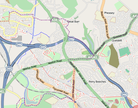
Map showing Great Barr Area

Mapping (c)  OpenStreetMap and  contributors cc-by-sa

Separate micro-sites cover Red HouseHamstead Colliery and Great Barr Hall.


About this site

If you have any old photographs you would like to see added to this site please send them to:


Anthony Lewis
4 Elm Drive
Great Barr
Birmingham
B43 6AT

Please provide as many details as possibleand include your name and address for return of pictures. If you want a copy of the scanned images please state so.

Condition of acceptance of photographs

While every care will be taken of photographs sent in no responsibility can be taken for pictures lost or damged in the post. Submission of photographs authorises the site operator (Publisher) to reproduce, publish, distribute and broadcast (or permit the same) all photographs and to include and make them available in any information service, electronic or otherwise. In particular, the contributor gives authority to the Publisher for the photograph to be disseminated on the Internet.

Acknowledgement - Express and Star

Some pictures are reproduced with permission from the Express and Star. Copies of some of these "Pictures from the Past" (as indicated with the picture, with original publication date) may be obtained from the Express and Star. Copies are approximately 10x8 ins and can be ordered by phoning 01902 319444

Copyright

Where indicated on pictures that the copyright is owned by www.b43.co.uk permission to reproduce will normally be given but must be formally requested.

In many cases the originator of the photographs are unknown and I will be happy to acknowledge any origins.

Web Site Development

Site hosted by Jab Web Solutions

www.jabwebsolutions.co.uk

Domain Names managed through:-

www.1aond1.co.uk

Web Utilities by ww.Bravenet.com :-

Acknowledgements

I would like to thank all those who have contributed to this site with pictures, information and memories.

Those who have provided information and pictures include:

  • Keith Berry - for some of his wonderful photographs
  • Robert Deloyde - for information relating to St. Margarets Church
  • Marg Macklin
  • Hanna Morrall  - for resources relating to Hamstead Colliery
  • Fred Probyn - for memories and photographs of Hamstead Colliery


I would also like to thank those who have provided snippets of information to build up the information available on the area, including: -

Richard Cliff, Greg Martin, Fred Morris, David Sealey, Suzanne Simcox, Kath Tucker, John Westwood, Michael Winstone.


B43 Postcode

Postal services were first defined in England by the 1710 Act for establishing a General Post-Office for all Her Majesties Dominions. It has been stated that British houses started being numbered after the Stamp Act of 1765, although this act was mainly concerned with taxing mail from the colonies to raise revenue. The first recorded house number was in 1708 and by the end of the century numbering was well established.

It seems formal requirments for numbering came in The Towns Improvement  Clauses Act of 1847 which stated
"The commissioners shall from time to time cause the houses and buildings in all or any of the streets to be marked with numbers as they think fit, and shall cause to be put up or painted on a conspicuous part of some house, building, or place, at or near each end, corner, or entrance of every such street, the name by which such street is to be known".

In many areas houses remain named but un-numbered. In Great Barr many houses on victorian maps were only known by their name. 

In January 1932 the Postmaster General approved the division of a nuwmber of large tons into numbered districts and In November 1934 the Post Office announced the introduction of the districts in "every provincial town in the United Kingdom large enough to justify it".

Pamphlets were issued to each householder and business in Birmingham notifying them of the number of the district in which their premises lay. The pamphlets also included a map of the divisions, and copies were made available at local head post offices.

The public were "particularly invited" to include the district number in the address at the head of all private or business letters and a publicity campaign in the following year was made to encourage the use of the district numbers. The slogan for the campaign was "For speed and certainty always use a postal district number on your letters and notepaper".

A poster was fixed to every pillar box in the affected areas bearing the number of the district and appealing for the public's co-operation. Every post office in the numbered district was also to display this information. Businesses were issued with a free booklet containing maps and listings of the correct district number for every street in the area

Each was divided into numbered postal districts. Some Birmingham codes were sub-divided, with a letter, such as Great Barr, Birmingham 22 or Birmingham 22a – as can still be seen on many older street-name signs.

The postal codes used in the United Kingdom ( known as postcodes) are  alphanumeric and were introduced by the Royal Mail over a 15-year period from 11 October 1959 to 1974.The earlier district codes were incorporated into the national postcode system. However B22 is not used as a postcode, the area being split into B42  and B43.

Postcodes are alphanumeric and between five and eight characters long (including a single space separating the outward and inward parts of the code).Great Barr having B43 as the outward part and the inward parts being 5 (Hamstead) or 6 (Grove Vale/Whitecrest) or 7 (Wilderness Lane, Chapel Lane,  Park Farm and Pheasey areas). 6 and 7 being divide by the M6.

The area bounded by Queslett Road and Walsall Road comes under B42.


 References: Wikipedia en.wikipedia.org/wiki/B_postcode_area

The British Postal Museum and Archive

www.doogal.co.uk/UKPostcodes.php


Bibliography

In developing this site many local books have been referenced.

  • Collins, Fran & Martin (2001) They also server who stand and wait - A history of Pheasey Farms U.S. Replacement Depot, Sub Depot of the 10th Replacement Depot 1942/1945, Brewin Books, Studley Warwickshire, ISBN 1 85858 204 0
  • Dilworth, D. (1976) The Tame Mills of Staffordshire, Phillimore London, ISBN 0 86033 216 8
  • Jones, John Morris, Manors of North Birmingham, City of Birmingham Education Department, ISBN 0 7093 0014 X (or X 2563196, 1984. Parts of this publication and many more by John Morris are reproduced online within the Birmingham Grid for Learning site Here
  • Meachem, Rodger Clive (1989), Victorian Hamstead: Its People, Its Colliery - An Illustrated History, 1870-1910, Brewin Books Limited ISBN 0947731385
  • Price, Terry "West Bromwich People and Places" which has a section including Great Barr.
  • Pugh, R,B. ed. (1964) The Victoria History of the Counties of England, A History of Warwickshire Vol. VII, University of London, Online at British History Online
  • Pugh, R,B. ed. (1976) The Victoria History of the Counties of England, A History of Staffordshire Vol. XVII, University of London, Online at British History Online
  • Stephens W.B. (Editor) (1969) A History of the County of Warwick: Volume VIII - The City of Coventry and Borough of Warwick . Online at British History Online
  • Wilkinson, Christine, and Hanson, Margaret (2003) Birmingham Cinemas,Tempus which has information about the Beacon Cinema

Copyright 2020 Great Barr Past and Present, Anthony Lewis

Administrator